Plotting air raids on Britain: map shows devastating impact of WWII Luftwaffe strikes
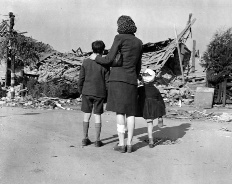
HO 192/626 Rocket bomb damage to Chrysler Works, London, 12 September 1944. Crown Copyright courtesy of The National Archives.
- Free digital resource launches on the 80th anniversary of the first bomb dropped in the UK during WWII – a previously under acknowledged date, 16 October 1939, at the Firth of Forth
A new interactive map has detailed every air raid across the UK during the Second World War –including the previously under acknowledged anniversary of the first ever attack on British shores, exactly 80 years ago today (16th October).
Developed by a University of York researcher, Bombing Britain: an air raid map uses wartime data to pinpoint more than 30,000 locations that were struck in the UK over the course of the War. The research carried out as part of the project has reconfirmed that the first area hit was not in fact London during the 1940 Blitz, as many people perhaps believe, but actually the Firth of Forth area in Scotland.
Published by Routledge, Taylor & Francis, the map, which is free to use, is based on 6,500 pages of brief, daily reports compiled by wartime intelligence officers for the Ministry of Home Security and senior officials. The reports are now held by The National Archives and have been digitised by Routledge, Taylor and Francis as part of their War, State and Society online resource.
By clicking on a pin on the map, people will be able to view and download data information on an air raid, including the date, location and number of casualties.
The map was researched by Dr Laura Blomvall from the Department of English and Related Literature at the University of York and is funded by the Arts and Humanities Research Council (AHRC) through The White Rose College of the Arts & Humanities’ (WRoCAH) Innovation Placement Scheme.
Dr Blomvall said: “This map offers an astonishing insight into the extent and scale of total war. Bombing Britain allows us to visualise how bomb strikes affected the entire country – not just London and the South East – as bombs were dropped from the Orkney Islands to Coventry, from Liverpool to the Scilly Isles and from Dover to Swansea – as well as this first attack in the Firth of Forth.
“This unique research project shows how war was ‘no longer confined to the battlefield’. The normalisation of aerial warfare turned mainland Britain into a violent battlefield, and the term ‘home front’ was no longer figurative.”
Dr George Hay, Military Historian at The National Archives, said: “The National Archives holds vast collections that tell the story of both the British and German strategic bombing campaigns of the Second World War. This interactive map makes use of the intelligence reports that followed German raids on the United Kingdom, and visually demonstrates the impact and reach of those attacks.
“This map will be a fantastic resource, not only for military and social historians, but for anyone interested in the impact of wartime air raids across the UK.”
Commenting on the launch Joseph Pettican, Digital Resources Publisher at Taylor & Francis, said: “We have been delighted to be involved with the release of the interactive Bombing Britain map, which we are very pleased to make free to the public, with the corresponding data free to download.”
FURTHER INFORMATION
Image: Crown Copyright courtesy of The National Archives.
'HO 192/626 Rocket bomb damage to Chrysler Works, London, 12 September 1944'
To arrange an interview, please contact:
Simon Wesson, Press & Media Relations Executive
Email: newsroom@taylorandfrancis.com
Tel.: +44 (0)20 7017 4311
Follow us on Twitter: @tandfnewsroom
Join the conversation: #AirRaidMap
or
Shelley Hughes
Email: shelley.hughes@york.ac.uk
Tel: 01904 323918
Details on first air raid: Luckily, no deaths or injuries were recorded in this first attack, however there was “great indignation” shown by nearby residents, as no public warning was set off when the bombs dropped in the Queensferry area.
Taylor & Francis Group partners with researchers, scholarly societies, universities and libraries worldwide to bring knowledge to life. As one of the world’s leading publishers of scholarly journals, books, ebooks and reference works our content spans all areas of Humanities, Social Sciences, Behavioural Sciences, Science, and Technology and Medicine.
From our network of offices in Oxford, New York, Philadelphia, Boca Raton, Boston, Melbourne, Singapore, Beijing, Tokyo, Stockholm, New Delhi and Cape Town, Taylor & Francis staff provide local expertise and support to our editors, societies and authors and tailored, efficient customer service to our library colleagues.
Routledge, Taylor & Francis is happy to make this interactive map free to the public/freely available, with the corresponding data free to download’
The Arts and Humanities Research Council (AHRC) funds world-class, independent researchers in a wide range of subjects: history, archaeology, digital content, philosophy, languages, design, heritage, area studies, the creative and performing arts, and much more.
This financial year the AHRC will spend approximately £98 million to fund research and postgraduate training, in collaboration with a number of partners. The quality and range of research supported by this investment of public funds not only provides social and cultural benefits and contributes to the economic success of the UK but also to the culture and welfare of societies around the globe.
Further imagery for usage
[caption id="attachment_2987" align="alignleft" width="469"]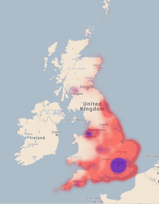 A heat map of United Kingdom, 1939-1945. The Colour red shows the density of air raids and the colour purple represents numbers of casualties (injured and killed)[/caption]